Day 48 - Thursday, June 28th - Brattleboro, VT to Burlington, MA
Distance: 92.9 miles
Elevation Gain: 4698 ft. or 31.75 ft./mile
Net elevation change: -167 ft.
Somehow it is only fitting that today is 93 miles AND almost 5000 feet of climbing and we will accomplish a first for the tour by crossing two state lines. I've had visions of the route designer just gleefully mapping this one out laughing to themselves saying "...you think you are done....ha....suck it up buttercup..." So here we go.
I wrote that paragraph at least two weeks ago. I forgot to add rain to the mix and didn't quite have a full appreciation of the quality of the roads, namely narrow, uneven (to be kind), and in my opinion, full of very impatient and at best, mildly aggressive drivers. I am not going to belabor the point. After 28 miles I chose the van. For me it was too dangerous. Chapeau to all those riders that gutted it out.
For the group, today was mostly southeast as we left the hotel and crossed the Connecticut River and about 2 miles later and entered New Hampshire for our 13th state line crossing and 14th state.
At mile 9 we reached Hinsdale, a town of about 4000, chartered in 1753 and named for Colonel Ebenezer Hinsdale, a member of a prominent Deerfield, Massachusetts family, whose mother had been taken captive in a raid by the French and their Indian allies and taken to Montreal in 1704. Hinsdale was ordained and became the chaplain at Fort Dummer, a trading post on the Connecticut River, and later enlisted in the army. In 1742, he established Fort Hinsdale, including a trading post and gristmill, reportedly at his own expense. It is also the home of the post office that has been in operation for the longest period of time.
Winchester was up next at mile 15. The town has a population of 4300 and was originally named Arlington in 1733, in honor of Charles Fitzroy, Earl of Arlington. It was established as protection for the Massachusetts border but was renamed when it became part of New Hampshire in 1741.
Between Hinsdale and Winchester we reached the Ashuelot Covered Bridge.
We got to Richmond next at mile 22. The town of 1100 was chartered in 1735 by the Governor of Massachusetts and set aside for soldiers returning from the war in Canada. Originally it was named Sylvester-Canada in honor of Captain Joseph Sylvester of Scituate, Massachusetts who was killed in 1690 during an attempt to capture Quebec. The town was renamed after it became part of New Hampshire and it was named after Charles Lennox, 3rd Duke of Richmond, a staunch advocate of colonial independence.
Groton was up next at mile 64 and has a population of nearly 11,000. The historic town was a battlefield in King Philip's War, a war in New England from 1675–78 between American Indian inhabitants and colonists and their Indian allies. The war is named for Metacomet, the Wampanoag chief who adopted the name Philip because of the friendly relations between his father Massasoit and the Mayflower Pilgrims. Groton was also a battlefield in Queen Anne's War (the second in a series of wars between France and England for control of North America), with children taken captive in a raid by Abenaki and French. It was also the birthplace of William Prescott, who commanded the colonial forces at the Battle of Bunker Hill.
Westford was next at mile 72. It has a population of nearly 22,000 and originally it was part of Chelmsford as West Chelmsford. It soon grew large enough to sustain its own governance, and was officially incorporated as Westford in 1729. In the late 18th and early 19th centuries Westford primarily produced granite, apples, and worsted yarn. The Abbot Worsted Company was said to be the first company in the nation to use camel hair for worsted yarns.
At this point in the ride there is roughly 22 miles to go to the hotel and you dear reader find out the truth. I don't have pictures or the research done to finish today's route. Suffice it to say that there is more history in this part of the country that I could ever summarize in an even remotely accurate fashion.
A Not So Sneak Peek at Tomorrow
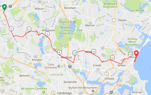
17 miles to the Beach


Smart move - better to stay safe. Today marks the end of the trail. Time to think about your next adventure.
ReplyDeleteRSRO,
Jim