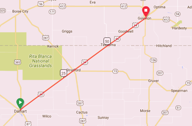
Day 19 - Wednesday, May 30th - Dalhart to Guymon, Oklahoma
Distance: 72.4 miles
Elevation Gain: 389 ft. or 5.4 ft./mile
Net elevation change: -865 ft.
Click Here to Ride Along !!
Today and tomorrow we will ride about 110 miles compared to
the 278 over the last three days. An additional bonus is the gross climbing is
almost Florida-like with under 400 feet each day. While the terrain was flatter and the distance shorter, the headwind was very similar to yesterday. Overall, not as tough as yesterday. It was nice to get to the hotel at a reasonable hour and be able to get a burger at a local place, Round Top Burgers and Pizza, located in a converted and renovated Quonset hut. Quite good!
We only got to Texas yesterday and today we left it and entered Oklahoma at about the 50 mile mark, our fourth state line crossing and fifth state. This might be the straightest route we have on the entire tour as we get on and stay on US 54 traveling Northeast the entire day.
We only got to Texas yesterday and today we left it and entered Oklahoma at about the 50 mile mark, our fourth state line crossing and fifth state. This might be the straightest route we have on the entire tour as we get on and stay on US 54 traveling Northeast the entire day.
Right out of Dalhart it is pretty obvious that we are back
traveling through farmland and at about the 19-mile mark we pass a series of
silos and grain elevators owned and operated by the Sunray Ag Cooperative. They are on the west side of the road that are
in the small amount of space between US 54 and the railroad.
Sunray Ag Cooperative began in 1939 when three local farmers decided that a farmer owned co-op was needed in the area so that producers could make collective decisions, have fair pricing and members would receive dividends at the end of each year. Over the years five grain elevators were added along with a farm and home store and Sunray boasts the longest rural elevator in the state of Texas.
Some shots from the ride out of town, the grain elevator, and a roadside stand cowboy that has seen better days.
These guys weren't scared.
More trains.

The landscape of seemingly never-ending farmland continues until about the 30-mile mark when we reached the outskirts of Stratford which seems like a community that grew up around a grain elevator that happens to be there right in the middle of town. What I learn over the course of the rest of the day, is that every town has a grain elevator, usually right on the main drag, next to the the railroad tracks.
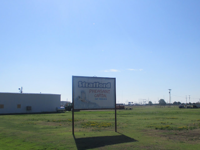
Stratford is a city of about 2000 people and the county seat of Sherman County. It is named after Stratford, Virginia, the boyhood home of Robert E. Lee and, at the 31 mile mark, is our only SAG stop for the day. The City Sign says it is the Pheasant Capital of Texas. It seems that pheasant hunting is a pretty big deal up here in the Panhandle.
We quickly returned to the farmland tour and at the 50-mile mark reach the outskirts of Texhoma, that just happens to be partially in Texas and part in Oklahoma. Texhoma is actually two small cities with the Texas Oklahoma border separating the two. About 350 people live in Texas and about 900 live in Oklahoma. Obviously we crossed into Oklahoma at this point. Some pictures from the SAG to Oklahoma.
Right about mile 61 we reach Goodwell home to Oklahoma
Panhandle State University and the No
Man’s Land Museum.
Goodwell, Oklahoma has a population of about 1200 and was
founded in 1901 when the Chicago and Rock Island Railroad established a switch.
It got the name Goodwell for the eminently practical reason there was a good well there.
The Oklahoma Panhandle State University is located in
Goodwell and opened in 1909. Alongside the traditional degree programs you
would expect to see in any college or university there is a
heavy emphasis in Agriculture related courses. I confess that I did not expect
to find a Rodeo team under the athletic programs.
The
No Man’s Land Museum is also located in Goodwell and was founded in 1934. It is dedicated to preserving the history of
what is now known as the Oklahoma Panhandle. The panhandle came into existence
in 1854 when the Kansas and New Mexico Territories were defined and the
Panhandle was retained by the US government as a Public Land Strip. The status
of the Panhandle remained unclear until 1890 when it became part of Oklahoma.
In the intervening years settlers established ranches and the Cherokee people
claim it is part of Indian Territory and the Post Office goes so far as to
establish post offices with the postmark NSIT (Neutral Strip Indian Territory).
Mile 70 brings us to the outskirts Guymon, OK, our stop for the night. Here are some pictures from our ride from Texhoma to Guymon.
Wind Farm
More Feed Lots
Sneak Peek at Tomorrow
Tomorrow is darn close to a rest day as we only have to go 40 miles to the northeast to get to Liberal, Kansas. Because of the short day we have a delayed start at 9 AM. I doubt that I will be able to sleep late. Tomorrow will be the first of seven nights we will spend in Kansas, including a rest day in Abilene next Tuesday.
Liberal, is the county seat of Seward County and has a
population of about 20,500. In 1872, an early settler S.S. Rogers built the
first house in what would become Liberal, KS. He was known for giving thirsty
travelers free water. Supposedly Liberal got its name from the common response
to his acts of kindness which was “That’s very liberal of you.” Natural gas was discovered west of the city
in 1920 and oil southwest of town in 1951. In 1963 the largest helium plant in
the world was opened. According to the
Trip Advisor the top two places to visit are the Mid-America Air Museum and
Dorothy’s House and Land of Oz.


Comments
Post a Comment